
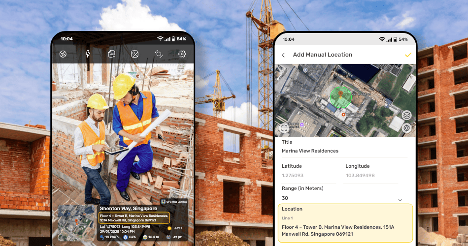
In the real world, you’re not always standing at the exact spot where work was done when you take a photo. Maybe the task was completed earlier. Maybe the area is locked, far, or not safe to enter. Or maybe you’re managing a large site, and walking back and forth just to take photos isn’t practical.
That’s why we built the Manual Location feature inside the GPS Map Camera app.
 -->
-->
It helps you set a nearby location manually, so your photo shows the right place, even if you’re standing a little away from it. But to keep your data genuine and trustworthy, we’ve added a smart limit.
✅ Only Nearby Locations Allowed—For Real Work, Not Fake Tags
When you use Manual Location, the app lets you select a place within 50 to 1000 meters of your current location. This range is enough to cover big sites and wide work zones.
But if you try to set a location that’s more than 1000 meters away, the app will not allow it.
Why?
Because allowing faraway, fake locations would make the data unreliable.
We want your photos to stay authentic and useful for reports, records, and client sharing.
📍 Use Manual Location for These Real-Life Situations:
You’re at the site gate, but the job happened inside a storage room.
You finished work in one corner of a farm but forgot to take a photo.
You’re doing maintenance on the 5th floor, but standing on the ground now.
You’re a delivery driver, and the drop-off was 200 m inside a large industrial park.
You’re documenting different flats in a building without going back up every time.
In all these cases, you can manually set the correct spot—as long as it’s within 1000 meters—and your photo will still tell the real story
🎯 Who Needs This Feature the Most?
👷♂️ Construction Workers & Site Supervisors
Big construction areas often mean the actual task and your current position are far apart. This helps tag the right zone, like “Tower A – 7th Floor Slab,” without walking there again.
🏘️ Real Estate Agents & Builders
Easily set the right apartment or plot name in a large property. No need to revisit each floor just to click photos.
🚛 Logistics & Transport Teams
Tag actual delivery spots or storage areas inside warehouses, even if you’re at the loading dock.
🧪 Survey Teams & Researchers
Field researchers can assign the correct zone or sample area, even from a safe or shaded place nearby.
🛠️ Repair & Service Technicians
Mark specific flats, AC units, or machinery sections when doing rounds in buildings or factories.
🌾 Farming experts & agri inspectors tag
Different parts of a large farm—like “South Field – Rice Area”—without walking into muddy or distant corners.
🏭 Factory Managers & Internal Auditors
Use it to tag different departments or machinery sections when taking safety checks or internal inspection photos.
📌 Remember:
Manual Location helps you save time, avoid repeated walking, and still stamp your photo with the right and real place.
But thanks to the 1000 m limit, it also protects you and your company from fake data, which is important for professional and compliance reasons.
Work smarter. Stay honest.
Use Manual Location—only where it makes sense.